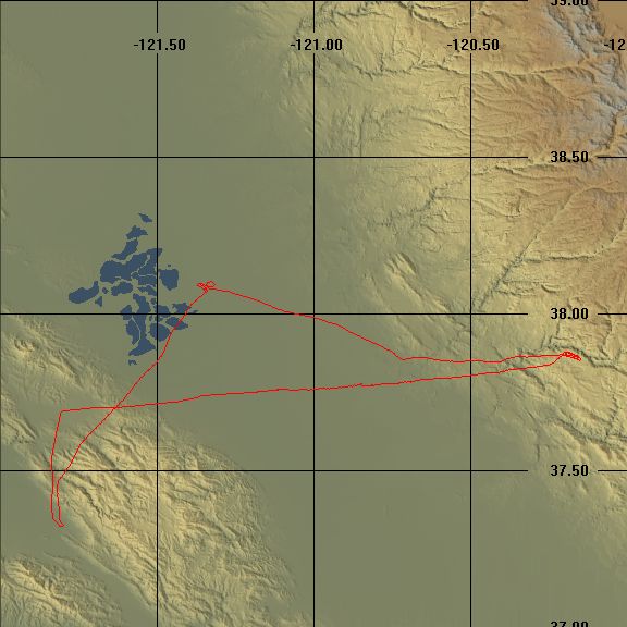
 The weather started off foggy, but was burning off quickly when I got to the airport about 11:30am. We were scheduled to fly at 12pm and I needed to complete the flight plan calculations given the forecast winds. I had the first half of the trip completed when Grainne showed up. She had a few questions about the route I had picked but nothing too serious. I had planned to fly a right 45 departure from RHV which is basically due North, climb to 4500’ and then turn East directly over Livermore and climb up to 5500’. That would set me up for a straight line course across the central valley passed Tracy and Oakdale and on to Pine Mountain Lake. For practice I had flown the route on FS2000 the last night and most of the landmarks I’d picked out seemed easy enough to see. The route back would use the 251 degree radial to the Manteca VOR which would take me neatly to the entry to Stockton class D airspace. Grainne had already told me we would probably not land at Stockton, but instead divert to somewhere else, I still had to plan it out though. I filed a flight plan for the outward journey.
A normal takeoff and as we climbed towards Calaveras Reservoir I called Oakland Flight Service Station and opened the flight plan, the guy was real nice, he needed to get my name, I guess the recorded message I left when I filed the plan garbled my it and he gave us a frequency for filing pilot reports (PIREPS) and position updates during the journey. We were just leveled off at 4500’ when I called Bay Approach to request flight following. I completely screwed it up, I forgot to tell him where I was, how high I was and what I wanted and I think I forgot to repeat my call-sign a couple of times. In the end he just gave me another frequency to call. I was completely flustered. I started from scratch on the new frequency and thankfully got it right this time – I’m still intimidated by talking to Bay Approach along with all the “real” air traffic in the congested Bay Area. The sequence is not hard, basically you initiate the call with “Bay Approach, Skyhawk 5766J, request”, then wait for them to reply usually with “Skyhawk 5766J, Bay Approach state you request”. Then you tell them where you are and what you want, “Bay Approach, Skyhawk 5766J, 10 miles North of Reid-Hillview, 4,500 feet, request flight following from Reid-Hillview to Pine Mountain Lake”. They then give you a transponder code to squawk, “Skyhawk 5766J, Squawk 0433 and IDENT”. You have to repeat the code back to them to make sure you got it right, “0433, 5766J”, enter it in the transponder and push the IDENT button, this will make it flash on their radar screen so they can pick it out easily. After that they will come back and confirm radar contact, “Skyhawk 5766J, radar contact at 12 miles north of Reid-Hillview, 4,600 feet” and they might ask you to confirm the altitude, “confirm altitude 4,600 feet” to which you reply “Affirmative, 4,600 feet, 5766J”. So you see, a piece of cake really. I was happily heading toward Livermore when they told me I was cleared to climb to 5500’ at my discretion and after that I didn’t hear from them until I was handed off to Stockton Approach somewhere over the Altamont Pass.
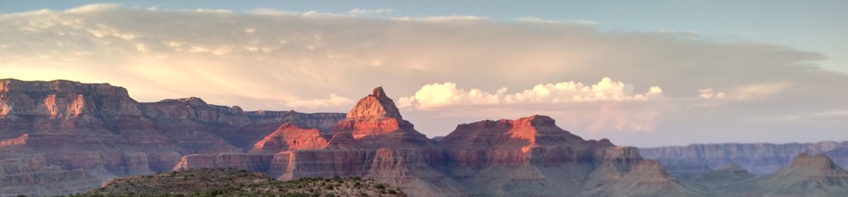
The flight went well out to Tracy, I was just a little south of my course at the intersection of I-205 and I-5. The next checkpoint was an intersection of a road and some power lines just outside Oakdale and we hit that one more or less on time. I missed the next checkpoint, it was supposed to be a intersection of a road and a railway, but I never saw it for sure. By this time I knew I was getting fairly close to Pine Mountain Lake, but I was not exactly sure where I was. Finally, I found a bridge that was unmistakable and would have been a much better checkpoint in the first place. Right then I realized that I knew just where I was, the road running across the bridge was highway 120 which is basically the route to Yosemite and I’ve driven it many times, there is a big hydro-electric plant close by that was easy to pick-out near a place called Priests Grade, that’s an incredibly steep hill that worth driving up, but will burn your brakes driving down (I know I’ve done it). Right about this time I saw the airport.
I was a little south of the field so as I descended I flew across it to enter on the downwind leg. I then proceeded to completely screw up the pattern entry. I flew way too close on the downwind, overshot a lot on the turn to final and decided to go around. As I climbed out two planes entered the downwind leg ahead of me so I was now number 3 to land. The wind was brutal, a lot of turbulence and it seemed to be coming from rapidly changing directions. I overshot final again and did another go around. This time Grainne started to talk me through the landing. Third time it worked, the approach was much better. We were just about 50 feet above the ground and for some reason the plane was just floating even with 40 degrees of flaps, suddenly the bottom dropped out and we headed for the ground fast. The flare worked and the actual landing was reasonable. We must have hit some kind of updraft followed by a downdraft just above the ground, it was no fun whatsoever.
Pine Mountain Lake is a “fly-in” community. People actually have houses right next to the taxiways and hangers instead of garages. We taxied to the transient parking and got out to stretch out legs. Grainne once again had to remind me to close my flight plan, which I did by phone. A few minutes on the ground and we decided to head back. Grainne had me do one more loop of the pattern and another landing to make sure I could be more consistent at an unfamiliar airport and to give me a confidence boast that the first landing wasn’t a fluke. The second landing was fine and we did a touch and go. This was probably a mistake because the altitude made the climb out much closer to the trees than either of us would have liked. We departed straight out and I had little trouble picking up the 251degree radial from the Manteca VOR. The air however was really bumpy, the worst turbulence I’ve been in so far, though Grainne said it was only “light”. Once we were back at altitude Grainne had me put on the foggles and I flew on instruments tracking the VOR. This was only hard because of the bouncing around and I did a passable job of staying on course. Of course, once I took the foggles off I had no idea of where I was, other than on the radial so Grainne picked the perfect time to decide to divert me to Lodi. Whether by design or accident Lodi happened to be right on the fold of the map, with the airport on one side and all the associated information on the other. The plane was bouncing around and taking most of my attention to keep it straight and level and I was trying to plot a course to the new airport. The first problem was I didn’t know where I was. I tried triangulating with the Linden VOR and got a rough idea, close enough to very roughly get a course of 285 degrees. Grainne suggested I use the DME (Distance Measurement Equipment) to get the distance to the Manteca VOR, thankfully this agreed fairly closely with my first estimate. Once I’d decided that about 280 was reasonable Grainne had me calculate the ETE (Estimated Time Enroute), the ETA (Estimated Time of Arrival) and the fuel required. Once that was done, I just set the GOTO on my GPS and it gave me a heading of 270 degrees and an ETA that matched mine to the minute (by luck I think).
Actually finding the airport turned out to be a little difficult, there were two airports marked close together on the chart, I could see one below me, but I couldn’t see the other so I wasn‘t sure if I had the right one or not. The ETA (and the GPS) were telling me I’d was over the right airport so I decided to descend and get a better look. I did a descending right turn and as I came around I saw the second airport confirming that I was in fact over the right place, Kingdon Airport. I did a thankfully uneventful entry into left downwind and made a fine landing. There were no taxiways, so we just turned around at the far end of the runway and took off again – there was really no significant wind to force us to take off in any particular direction. We did a crosswind departure which was basically towards home and Grainne told me to just find the fastest way back to RHV.
I could see Mt Diablo in the distance. Reid-Hillview was too far to come up on the “nearest” list on my GPS, but Livermore did so I set that as my destination. I’m pretty familiar with the central valley around Stockton and Tracy so it was easy to set myself up in the right direction. Coming over the Altamont Pass again I could see Mission Peak in the distance, Calaveras Reservoir is right in front so we just made a beeline for familiar airspace. I tried to get a radial from the San Jose VOR, but the mountains got in the way and I didn’t really need it anyway. I got the RHV ATIS and called into the tower over Calaveras. We did a completely standard approach to right traffic for runway 31R though my attempt at a soft-field landing left a lot to be desired.
The trip was fun, though somewhat tiring, almost 3 hours flying and over 200 nm traveled. Other than the problems landing at Pine Mountain Lake it was a good experience. I really didn’t screw anything up badly. I think once I get some more local solo experience I’ll be more than ready to attempt one of these trips on my own.