 I didn’t get to fly on Thursday, the wind was 14 knots when I arrived at the airport and my solo limit is just 12 knots headwind. So I was really keen to get into the air today. This was my first cross-country flight. We flew from RHV to Castle (MER) near Merced in the Central Valley.
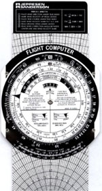
 I had spent about an hour of ground time with Grainne on Wednesday evening to preview the flight planning, we picked out the route and landmarks, measured the leg distances and calculated the headings given an assumed wind. All this using the high tech cardboard E6B flight computer. I also called Oakland Flight Service Station (FSS) and got a standard weather briefing, unfortunately I forgot to tell him I was a student and he rattled through the briefing so quickly I barely wrote down 10% of what he said. Still, I got the feel for what was going on. I studied the ground school CD’s for the cross-country on Thursday night and finally learned how the E6B is really used (I was a bit bemused with what Grainne was telling me the night before). For a child of the computer age, having never even seen a slide-rule I was amazed at how clever the little gadget was – in fact better than the electronic version I’ve been playing with in my Palm Pilot – much more intuitive. For the aviationally challenged an E6B is a rotary slide-rule setup for doing common aviation calculations like “how many minutes to fly 15 miles at a speed of 115 MPH”, or “how much fuel is used in 15 minutes with a burn rate of 8.6 GPH”. The back side also has a very clever method of calculating how the wind effects the direction and speed of flight, for example finding how much headwind or tailwind you have and how it will effect your ground speed and your direction.
On Friday night I setup FS2000 with the current weather conditions, redid the calculations and flew the route on the simulator. This went well though some the landmarks I had picked out were really hard to identify. The fight was great until I crashed on landing at Castle – stupid simulator, doesn‘t it know I can land a real airplane on my own!
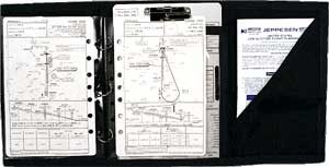
So Saturday morning the marine layer fog was a solid overcast when I arrived at the airport at 10am. Grainne and I planned to spend an hour getting the current weather conditions and making the final calculations for the flight plan. This all went well, we started by going through the weather on DUATS which is an online service contracted by the Government to provide pre-flight information. Then I called the FSS again and remembered to tell him I was a student and got a standard briefing. No bad weather once the fog burned off. The guy must have repeated “Don’t go until the fog is gone” about three times. I filed the flight plan over the phone, you can do this by just leaving a recording, pretty cool. In the end we waited until 12:00pm until the sky was clear enough to get going. I finally got to use the kneeboard I bought back in August. I got it after the flight in 8276E which had no side pockets. After that flight I never bothered to use it because it just seemed like overkill and I never flew in 8276E again. Normally, I just have my checklist card, with a small note-pad attached to it with a bull-dog clip and a pen slipped over the top. The knee board is a fancy thing full of pockets that attaches to your knee with a strap and holds all the goodies you need for cross-country flight.
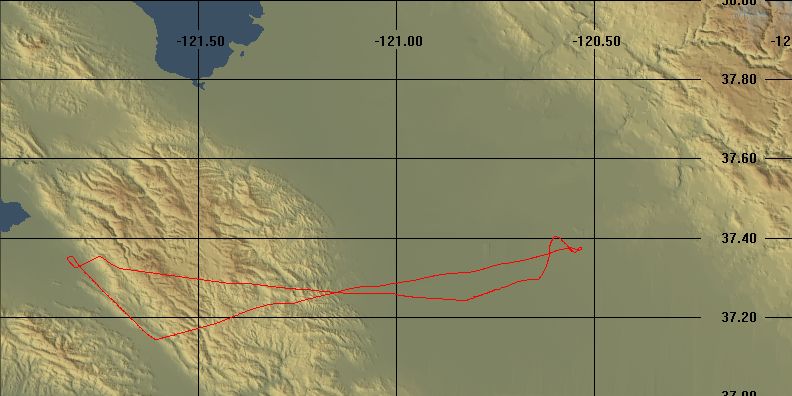
 Had a standard pre-flight, taxi, we got off the ground at 12:32pm and departed downwind towards Anderson Reservoir. Did the climb checklist and for the first time actually called Oakland FSS to open my flight plan. Then we called Bay Approach and got flight following, this worked well though I’m still a little nervous talking to the big boys. They all sound so busy and hearing all the commercial air traffic makes me feel like I’m interrupting a bunch of busy people at work with my little joy ride to Merced. We climbed to 5,500’ and the first checkpoint on the trip, I arrived 1 minute late to my calculated value. It was then a short 2 minute trip to the first and only turn on the route, over the south shore of Anderson. We turned inland to head towards Castle. The air was smooth but there was a lot of haze so visibility was only about 7 miles. The next checkpoint was a line of three peaks, we were supposed to pass just to the right of the middle one. I thought I could see the landmark ahead of me. But it didn’t seem right, then Grainne pointed out a peak on my right we were just passing that seemed to be the one. Mountain peaks like these make poor landmarks, but there wasn’t much else around I could have used. About this time Bay Approach handed us off to Stockton Approach. The next landmark was easy, a road and railway parallel, running between two towns with Gustine airport off to the right. With the low visibility, I couldn’t see Castle, but I started my descent when the watch said I should and we saw the field about 7 miles out (I was also cheating the whole time, because I had my GPS fixed to the yoke with rubber bands – this was real useful for making sure the heading I had calculated was right). In the event the wind wasn’t as strong as forecast, so my heading had us drifting northwards a little, you can see the little kinks in the ground track where I made corrections.
Once I got Castle in sight, I reported I could see it to Stockton Approach and they terminated flight following and told us to squawk 1200 again. I couldn’t raise anyone on the Castle CTAF frequency to find out the runway in use so I over-flew the windsock at 2000’, it seemed to show a crosswind, but slightly favored runway 31. Castle is an old Air Force base, it has an 11,800’ x 300’ runway that can take B52 bombers, you could land five Cessna 172’s in formation on the runway it’s so huge. I started a left 270 degree turn to come in on the right 45 for runway 31 when Grainne pulled the engine to simulate a failure. I made it around the turn though it was a bit messy as I was trying to pitch for best glide at the same time. Didn’t bother with checklists and just headed straight onto the base leg. I was way high coming in over the numbers, but who cares I had 4 time the usual runway to land on. The landing was good. I was worried that the enormous scale of the runway would cause me to mistime the flare, but it didn‘t. Even the center strip painted on the runway was about 4 times wider than I was used to. The place was empty, we saw one Cessna 152 on a taxi way and another plane landed while we taxied back to the start, that was it. I believe there is a cool aviation museum somewhere close by, but we went straight back to the runway to head home.
Grainne had me try my first soft field takeoff which was poor, I didn’t realize just how much forward pressure is needed to keep the plane in ground effect. Still we got off OK. We were just climbing through about 200’ when she pulled the engine again to simulate a failure on take-off – life would be nice is these only happened on 11,800’ runways. I still had half the runway to land on. Got myself configured to land and would have made it easily when Grainne said to go-around, so full power again and flaps back up and we made a crosswind departure. About this time Grainne asked me what I had forgotten in the post-landing checklist – I couldn’t think of anything until she told me. Duh, I had forgotten to close my flight plan – if you don’t close it they fear the worst and come looking for you. Grainne took care of this as we climbed back up to 4,500’. It was a bit finicky, you have to transmit on one frequency on the radio and listen on another frequency on the navigation radio for the reply, it took a couple of tries but she finally got it to work.
On the way back we used radio navigation as opposed to the pilotage and dead reckoning we used on the way out. We intercepted the 260 degree radial on the Merced VOR (a special type of transmitter that sends radiating spokes of signals out in all directions). This radial gave us a straight line course back to Mt. Hamilton. The ride back was nice, but really started to get bumpy over the top of the mountains. Mt. Hamilton is 4,200’ high, I was really quite nervous flying over at just 4,500’ so I let the altitude creep up to 4,700’ as we crossed over. The view of the lick observatory was spectacular. We got the current ATIS and I called into Reid Hillview Tower, they told me to enter on right base for 31R and report two miles. I started descending, but this is tricky on this approach to RHV. The mountains drop away very steeply just about 4 miles east of the field, so even if you just clear the last ridge line you are still way too high to land. So we did a forward slip to loose the altitude – which once again went poorly. Grainne had to help me get into the slip and the plane was yawing every which way. Still we got down and I was cleared to land on 31R when I reported in at 2 miles. The landing was fine. Today was a really fun flight and I’m looking forward to more cross-counties.
